ICSE Geography Map Class X.pdf
•
13 likes•30,072 views
For my handwritten notes of ICSE subjects, visit: linktr.ee/icsenotes I scored 100/100 in ICSE Geography, and here are my maps! These map works are as per the ICSE Syllabus, and were provided by my Geography teacher. Later, I researched on the internet extensively to ensure all markings are accurate. Each page includes some instructions (copied from “Analysis of Pupil Performance” issued by ICSE Board) at the bottom. They will assist with proper marking. The maps are as accurate as I could make them. Nevertheless, human error might've crept in, so follow your teachers' advice first and then refer to it.
Report
Share

More Related Content
What's hot
What's hot (20)
Recently uploaded
Recently uploaded (20)
ICSE Geography Map Class X.pdf
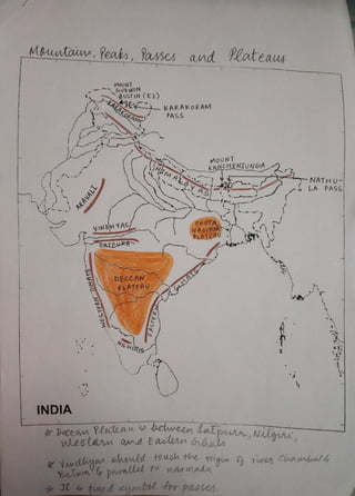
- 1. Moutaw, Peabs, asses and Plateay INDIA WESTERN GTATS ARAVALI MoUNT AUSTIN (k2) KARAKORAM VINDHYAS/ SATPURA DECCAN pLATEAU NIL GIRIS i KAR AKORAM PASS EASTERa MOUNT a s a A T S KANCHENTäNGIA CHOTA NAGIPUR PLATEA0 wLeslarn and EaalenGbats -NATH u -5 LA PASS shsuld to uch the oign 5h Tive Chambal4 Bewn parallel to nAN mada passes.
- 2. GULF OF kuT CH G0LF bF KHAMBHAT INDIA Kuvers and Watr bodes R.s H A M B A L R. NARM ONG KRISH wULAR LAKE . B E HADA RA NA BRAHMAPUTRA GyANG A R MAH DAMODAR NADI CHILKA LAKE ANDAMAN SEA NWULAR LAKE Toucho Hhe morthen bend s Thelum MiGtee amts map- lbel jamlna Nor betven
- 3. INDIA Plais and eret THAR DESERT KON KAN CoASL MALABAR COASI M CoR oM ANDEL Gransue plno DAIAS R C A R S J N O R T H E R N not be shadd
- 4. Lalitudes and leugituds,South uleot Monsens S o U T H - W E S T M O N S O o N A R I A B l A N TROPid of , S E A B R A N C H INDIA wvth s name STANDARD MERIDIAN INDA H(s2'30'e) W E S T M O S o o N BAY O f BENGAL B R A N c H 23%°N along dedtagArd Mehidian alld no cut ori Lanka.
- 5. fotulation and Nailheast Monsoons. JAMMU AND KASHMUR/ INDIA KERALA LADAKH eiHAR WEST BENGAL SIKKIM N O R T H -tAST MONS 0 ONS AN AREA OF SPARSE AN AREA OF DENSE POPULAT|ON POPULA TION
- 6. citil aud Distributou of Mirals MUMBAI HIGHe (oFf-SHO RE OlL FIELD INDIA PEL vELHI (onumeAI (BENGAWRU YDERABADIsHAKHAPhTNA CHEJINAI JHARIA (COAL IELDS KOCHL/ KoLKATA M tothe east s) te mdaton and at exaclyomthe ape tert eiis must net entend mts wale bodis
- 7. BLACK SoL CoasTAL ALLUVIUM INDIA eoASTAL ALLUYIUM LbECTA|C ALLUVIUM frr alluval plaina in eoUlh lrdia Ahade the euilr weetseast caol. broad RED SoIL